Here is the latest from the National Hurricane Center on Zeta.
- ZETA CONTINUING TO STRENGTHEN.
- LIFE-THREATENING STORM SURGE AND STRONG WINDS EXPECTED ALONG PORTIONS OF THE NORTHERN GULF COAST BEGINNING AROUND MIDDAY.
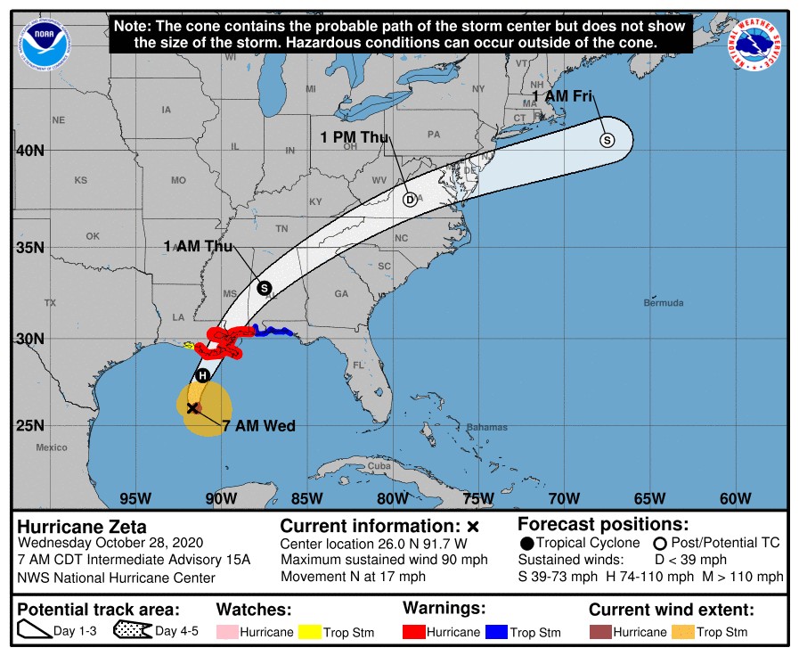
– A Hurricane Warning continues for Morgan City LA to the Ms/AL state line, including Lake Pontchartrain, Lake Maurepas, and Metropolitan New Orleans. Hurricane conditions are expected there this afternoon, with tropical storm conditions beginning later this morning. Preparations to protect life and property should be rushed to completion. Damaging winds, especially in gusts, will spread well inland across portions of southeast Mississippi and southern Alabama this evening and tonight.
– A Storm Surge Warning continues from the mouth of the Atchafalaya River to Navarre FL, including Lake Borgne, Lake Pontchartrain, Pensacola Bay, and Mobile Bay. The water could reach the following heights above ground somewhere in the indicated areas if the peak surge occurs at the time of high tide…
– Mouth of the Pearl River to Dauphin Island AL…6-9 ft
– Port Fourchon LA to the Mouth of the Pearl River incl.Lake Borgne…5-7 ft
– Dauphin Island AL to AL/FL state line…3-5 ft
– Mobile Bay…4-6 ft
– Mouth of the Atchafalaya River to Port Fourchon LA…3-5 ft
– Lake Pontchartrain…3-5 ft
– AL/FL state line to Navarre FL inc Pensacola Bay…2-4 ft
– Intracoastal City LA to the Mouth of the Atchafalaya River including Vermilion Bay…1-3 ft
– Navarre FL to Yankeetown FL including Choctawhatchee Bay and Saint Andrew Bay…1-3 ft
– A Tropical Storm Warning continues from the MS/AL state line to Walton/Bay County Line FL. Tropical storm conditions are expected there by late today.
– A Tropical Storm Watch continues from west of Morgan City to Intracoastal City LA. Tropical storm conditions are possible there this afternoon.
A few tornadoes are expected this afternoon through tonight over southeastern parts of Louisiana and Mississippi, southern Alabama, and the western Panhandle of Florida.
At 7 a.m. CDT, the center of Hurricane Zeta was centered over the Gulf of Mexico about 265 miles (430 km) southwest of the mouth of the Mississippi River and about 295 miles (470 km) south-southwest of New Orleans, LA. Zeta is moving toward the north near 17 mph (28 km/h). A faster northward to north-northeastward motion is expected to begin later this morning. On the forecast track, the center of Zeta will approach the northern Gulf Coast this morning and make landfall in southeastern Louisiana this afternoon. Zeta will move close to the Mississippi coast this evening and move across the southeastern and eastern United States on Thursday.

Maximum sustained winds have increased to near 90 mph (150 km/h) with higher gusts. Hurricane-force winds extend outward up to 35 miles (55 km) from the center and tropical-storm-force winds extend outward up to 150 miles (240 km). Some additional strengthening is forecast to occur this morning, and Zeta is expected to reach the northern Gulf Coast as a hurricane before weakening over the southeastern United States on Thursday.
Locally heavy rains in advance of Zeta will continue to expand and move north from the central Gulf Coast today, eventually affecting the Ohio Valley to the central Appalachians tonight and Thursday. Meanwhile, the core of heavy rains near Zeta will track from the central Gulf Coast to the Mid-Atlantic this afternoon through Thursday evening. Rainfall totals of 2 to 4 inches with isolated amounts of 6 inches are expected across these areas, resulting in flash, urban, small stream, and minor river flooding.

The next complete advisory will be issued by NHC at 10 a.m. CDT
The post Zeta continues to gain strength appeared first on News Mississippi.